On a perfect Melbourne winter's morning, six Walkabouters and four guests
met at Federation Square and set off for an 8 km walk through
the Royal Botanic Gardens.

It was a good thing that the campfire was going because it was sooo cold!

We gathered around the campfire in an attempt to capture it's warmth, before heading off at a brisk pace, upstream, along the path that follows the Yarra River.


The city shone in the winter sun as the leafless boughs of trees reached over the waters edge. The path took us through Birrarung Marr Park and we stopped to look at various interesting sculptures along the way.


We crossed over the Yarra River on the Olympic Boulevard bridge and then walked up a short incline into the Royal Domain Gardens and joined the path leading towards the Royal Botanic Gardens.
We entered the Gardens through the Lych Gate.


(I looked this up on google 'cause I thought it was a spelling mistake but Lych is correct.)
A Lych Gate, for those who have forgotten, is a covered gateway that was built at the entrances to old English Church yards. The word lych comes from the old English word for corpse, so a Lych Gate is where the corpses were carried through before burial.
Anyway, we walked through the Lych Gate and were immediately struck by how luscious and vibrant the plants looked from the recent abundant rains after so many years of drought and water restrictions. Following the path past the Huntingfield Lawn we arrived at the Temple of the Winds.


The Temple of the Winds was built in 1901 on top of the hill and has commanding views over the Gardens and north, across the Yarra towards Richmond.
After a short stop to take in the views, we continued along the path down through the 'grey garden' beds,


past the Plant Craft Cottage,


...down some steps...


...and past the Northern Lawn.


The large ornamental lake was originally a billabong created by the meandering flow of the Yarra River. It provides a wonderful home for local bird life and aquatic creatures including eels. Thoughtful plantings of large trees and shrubs by Guilfoyle all those years ago has created a beautiful backdrop for the lake which make for beautiful gardenesque views.
The land that was set aside for the establishment of Royal Botantic Gardens in 1846 by Lieutenant Governor Charles La Trobe. Originally swampland, the area was drained and billabong was 'cut off' from the Yarra River which created the Ornamental Lake.

We walked around one of the small inlets and onto Long Island via a short bridge. Here we looked across the water towards one of the small islands and


enjoyed how the light played with the reflections on the rippling water.


After crossing Long Island we emerged on to Dog Flat just below the Hopetoun Lawn,

where an interesting large-leafed tree with a vibrant red plant growing at it's base,
caught our attention.
caught our attention.
 |
| This new leaf looks just like a swan. |
This tree is a fig tree that originates from the highlands of Papua New Guinea. It's scientific name is Ficus dammaropsis or is commonly known as the Highland Breadfruit or 'Tok Pisin' in local Papuan dialect.
 |
| The fruit of a Breadfruit Tree. |
We were not sure of the name of the vibrant red plant, but it was very vibrant!!
 |
| Mystery red plant |
If anyone knows what this plant is called please, leave a message below!
We continued on until we found a resting opportunity, one of many that are scattered throughout the Gardens.

On the way out we noticed another interesting plant that seemed to have a flower on it's leaf.
After closer inspection we found that indeed, there were many flowers emerging form the centre of the leaves of this plant.

This plant is called Ruscus hypoglossum and it is from the Asparagacaea family. This particular species originates from Central and Southeast Europe (Source: wikilink).
Continuing on, we wandered past the popular Cafe and Restaurant on the Terrace next to the Lake and headed towards the Volcano!
Along the path, a surprise waited from us in some low growing trees...


....it's not every day that you see a kookaburra this close to the city!
(There were actually three of them, 2 were camera shy!)
We walked up hill following the paths through the Eastern Lawn and arrived at Guilfolye's Volcano!
No, it's not a real volcano that spews ash into the air and stops airplanes in their tracks,

it is actually a reservoir built in 1876 to store water to be used for the Gardens.

The Volcano's reservoir was the main water supply to the Gardens for over 70 years before it fell into disrepair and lay dormant and overgrown for about 60 years. Over the last few years the team of gardeners at the Royal Botanic Gardens have worked to redesign and restore the Volcano. The pictures above show the results of their hard labour.

It looks fantastic!
Unfortunately the Volcano's lining leaks and is currently empty for repairs. So that will mean another trip to visit the Volcano in the future.
We continued on, past some more resting opportunities

and had lunch on the lawn next to the old Observatory Buildings

before wandering back through the Gardens on the homeward stretch.
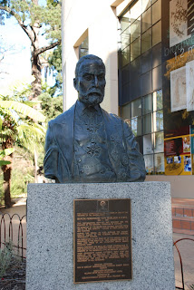
The picture below is a bust of Ferdinand von Mueller who was the first director appointed to the Gardens in 1857.


William Guilfoyle, the second director of the Gardens, constructed the reservoir in the form of a volcano to provide a gravity fed irrigation system to water the plants.


The Volcano's reservoir was the main water supply to the Gardens for over 70 years before it fell into disrepair and lay dormant and overgrown for about 60 years. Over the last few years the team of gardeners at the Royal Botanic Gardens have worked to redesign and restore the Volcano. The pictures above show the results of their hard labour.

It looks fantastic!
Unfortunately the Volcano's lining leaks and is currently empty for repairs. So that will mean another trip to visit the Volcano in the future.
We continued on, past some more resting opportunities

and had lunch on the lawn next to the old Observatory Buildings

before wandering back through the Gardens on the homeward stretch.
The picture below is a bust of Ferdinand von Mueller who was the first director appointed to the Gardens in 1857.

Among his other horticulture achievements, he is also noted for scattering blackberry seeds on many of his wanderings through Victoria because he thought the berries from the bushes would provide travelers nourishing, tasty treats on their travels.

We saw some magic puddings,
Thanks Ferdinand, for the many scratches and torn clothes over the years!


and a see through out-house that would be great for growing berry canes over,

and a sculpture with Snow Gums.

We gazed longingly at the seats in this lovely pavilion but kept walking.
With so many fascinating plants from all over the work and great views of gardenesque landscapes, our walk covered just a small sample of what the Gardens have to offer.
The Royal Botanical Garden's website is a great site to visit for lots more information.
With so many fascinating plants from all over the work and great views of gardenesque landscapes, our walk covered just a small sample of what the Gardens have to offer.
The Royal Botanical Garden's website is a great site to visit for lots more information.
We exited the Gardens via Gate H and joined the many people exercising on 'The Tan' and walked downstream along the Yarra, past the rowing clubs...


...and finished our walk wandering along St Kilda Road looking at the many stalls offering handcrafts at the Sunday Art's Centre Market.
Thank-you everyone for making this such an enjoyable walk
on such a wonderful Winter's day!
Walkabouters Club of Victoria Inc.
A0019863A